Glacial trough lakes and fjords – deep, blue, beautiful, inviting. Several weeks ago, while developing materials for a new course on geology through the movies, we watched the 2015 Norwegian disaster/action-thriller The Wave, in which a rockfall high above the Geiranger Fjord creates a displacement wave (landslide-generated tsunami) up to 80 m high that destroys the town of Geiranger and quite a few movie-lives along with it. This future-fictional event is based upon a real happening in 1934 when a landslide-generated wave in nearby Tafjorden killed 40 people. While the 1934 event is way too far back in time to investigate with satellite imagery, the 2007 Chehalis Lake, British Columbia event is worth looking at with HazMapper and the 30 m Landsat 7 data set.
On December 4, 2007, a 3 million m3 rock slide – debris avalanche initiated on the east face of 1,563 m high Mount Orrock, British Columbia. The debris avalanche descended 550 m before entering into 175 m-deep water of Chehalis Lake, a glacial-trough lake formed in the Pleistocene by advance and retreat of the Cordilleran Ice Sheet.

Upon entry into the lake, the debris avalanche generated a destructive tsunami that traveled the lake’s length and continued down the Chehalis River for at least 15 km (Roberts et al., 2013). The tsunami had a maximum run-up height of 37.8 m (124 ft) above lake level directly across from the debris avalanche entry point and 6.3 m (20.7 ft) at the lake’s exit, 7.5 km away. Because the event occurred in winter and in a fairly remote location, there were no eye-witnesses or casualties. In the summer, the lake is a popular location for camping, hiking, and fishing. All three of the campgrounds at the lake were damaged by the tsunami. Steve Ward, an emeritus professor at UC Santa Cruz, has posted a YouTube video with model simulations of the 2007 Chehalis Lake landslide and tsunami that are worth a look.
Using the 30 m Landsat 7 imagery, the rockslide-debris avalanche footprint and the trim line around the lake are quite visible via HazMapper. In the rdNDVI (pre-post relative difference in Normalized Difference Vegetation Index) image below, we choose to use an 18-month pre and post-event analysis window. We did this for two reasons. First, the event happened in winter at 49.4° N, so there are seasonal differences in vegetation and often snow on the ground. If we were using Landsat 8 or Sentinel-2 data, for example, we likely could have decreased the analysis window to 6 months pre/post-event to capture the rdNDVI signal successfully. However, because of the Landsat-7 instrument failure in 2003 resulting in the scan line error, increasing the analysis window to 18-months in both directions results in a reasonably clean rdNDVI change image, as can be seen below. Here is the direct HazMapper link for the analysis image presented below. It is fun and useful to experiment within HazMapper to get a feeling for how changing the Pre-and-Post Event Windows’ duration impacts the results when using Landsat-7 data after the May 31, 2003 failure of the Scan Line Corrector.
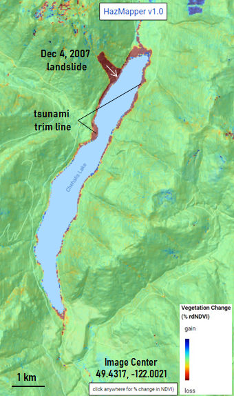
As we have seen with earlier posts, HazMapper is useful for identifying areas where vegetation has been lost and where vegetation is returning to previously disturbed parts of the landscape. The HazMapper rdNDVI result below shows the revegetation of the landslide mass and areas below the tsunami trim line in blue colors across an 18-month pre-post analysis window centered on June 4, 2009, again using Landsat-7 data.

We know that rapid-moving landslides entering into deep bodies of water can generate displacement waves. Is there evidence in the sediments of lakes for such events? Indeed there is. To our knowledge, the sediments in Chehalis lake have not been cored (recovered) yet to evaluate the sedimentary characteristics of the deposit associated with the 2007 event. Not too far away, however, on the north side of the Olympic Peninsula of Washington State, Lake Crescent’s sediments have been cored. The sediments from Lake Crescent record spectacular evidence for past landslide disturbance, as reported in a 2019 article in the Geological Society of America Bulletin by Dr. Elana Leithold and colleagues.
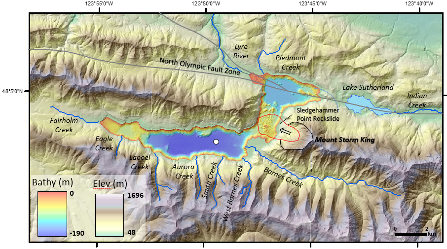
Leithold’s team identified four ‘megaturbidite‘ layers in the past ~7200 years (see below), each of which may have been caused when large landslides, likely triggered by local earthquakes, entered into the lake. The most recent megaturbidite was deposited about 3,100 years ago and recorded both an earthquake on the along the North Olympic Fault Zone, that trends beneath the northern part of the lake, and the triggering of a landslide from the west slope of Mount Storm King, known as the Sledgehammer Point rockslide.
The Sledgehammer Point slide entered waters that were at least 140 m deep, and is estimated to have rapidly deposited about 7.2 million m3 of rock and debris into Lake Crescent in a matter of seconds.

The megaturbidite deposited in response to the Sledgehammer Point Rockslide is over 165 cm thick. The average sedimentation rate at Lake Crescent is closer to 0.1 cm per year (Leithold et al., 2019). Therefore, the megaturbidite represents a ~1,650 times increase in lake-bottom sediment accumulation compared to the background rate. The figure below shows a photograph and the grain size distribution of a portion of one of the sediment cores recovered from the deep basin to the west of the rockslide deposit.

Clark and colleagues (2015) used data on the maximum observed height of landslide-generated tsunami waves worldwide as a function of the landslide volume to derive a regression equation relating the two parameters. Leithold et al. (2019) updated this database and used it to estimate the range of maximum run-up heights for the Sledgehammer Peak rockslide into Lake Crescent 3,100 years ago. The maximum wave run-up height on the opposite shore to the rockslide entry point is estimated to be somewhere between 82 to 104 m above lake level!
At Chehalis Lake in 2007, the maximum observed tsunami run-up was 38.6 m. Applying the regression equation reported in Leithold et al. (2019) results in a predicted run-up height of 62 m at Chehalis Lake. However, what is not well constrained is the slide that entered the lake. Perhaps the volume of rock and debris that entered into Chehalis Lake is closer to about 1 million m3, which using the regression equation, would result in an estimated maximum opposite shore displacement wave of around 37 m, close to the observed value. Of course, variations in bathymetry or the volume of entering rock and debris will lead to real-world deviations from a simplified prediction.

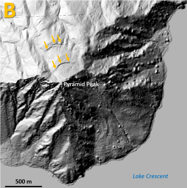
Let us bring this post back full-circle to the Norwegian disaster-thriller The Wave. The geologists’ job in the movie is to monitor a large crack in the mountainside high above the fjord. This crack fails catastrophically, leading to the rock avalanche that descends into the fjord and causes the tsunami. The State of Washington maintains a public-facing lidar portal, where anyone can view the most up-to-date high-resolution topographic data. Recently, they posted the Olympics North Opsw 2018 data set, which includes the high terrain on the north side of Lake Crescent. Low and behold, look at these lake-facing scarps (cracks) that sure look like they might be caused by slow, incremental rock mass movement above where we know older rockslides into the lake occurred (Leithold et al., 2019). See locations A & B on the figures below. Could they fail catastrophically? Will a future landslide-lake tsunami-megaturbidite event happen again at Lake Crescent? My bet is on ‘yes.’ The question then is when?


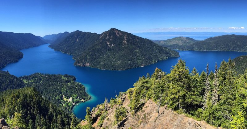
Lake Crescent is a beautiful spot on the northern Olympic Peninsula. Plan your visit today, for if you don’t, you will be one year older when you do. But when you are there, don’t forget to consider the landslide-tsunami story that is partially masked by the flanking forests and submerged beneath the lake’s azure-blue waters.
References:
Brideau, M.-A., Sturzenegger, M., Stead, D., Jaboyedoff, M., Lawrence, M., Roberts, N.J., Ward, B.C., Millard, T.H., and Clague, J.J., 2012, Stability analysis of the 2007 Chehalis lake landslide based on long-range terrestrial photogrammetry and airborne LiDAR data: Landslides, v. 9, p. 75–91.
Clark, K.J., Upton, P., Carey, J., Rosser, B., and Strong, D., 2015, Tsunami and seiche hazard scoping study of lakes Tekapo, Pukaki, Ohau, Alexandrina, and Ruataniwha:
Geological and Nuclear Sciences Limited (GNS Science) Consultancy Report 2014/227, 82 p.
Leithold, E.L., Wegmann, K.W., Bohnenstiehl, D.R., Joyner, C.N., and Pollen, A.F., 2019, Repeated megaturbidite deposition in Lake Crescent, Washington triggered by Holocene ruptures of the Lake Creek-Boundary Creek fault system: Geological Society of America Bulletin, v. 131, p. 2039–2055.
Roberts, N.J., McKillop, R.J., Lawrence, M.S., Psutka, J.F., Clague, J.J., Brideau, M.-A., and Ward, B.C., 2013, Impacts of the 2007 landslide-generated tsunami in Chehalis Lake, Canada, in Landslide science and practice, Springer, p. 133–140.
Viard, T., 2017, Hydraulic 2D Model of Landslide Generated Wave–Cases of Chehalis Lake and Chambon Lake, in Proceedings of the XXIVth TELEMAC-MASCARET User Conference, 17 to 20 October 2017, Graz University of Technology, Austria, p. 113–118.
Wang, J., Ward, S.N., and Xiao, L., 2015, Numerical simulation of the December 4, 2007 landslide-generated tsunami in Chehalis Lake, Canada: Geophysical Journal International, v. 201, p. 372–376.

Karl this is great! Sophisticated, intelligent communication that is well presented. I am sending it on to Pat Willits, Bruce and Annette Wendel *who serves on the Lake Crescent Owners Associationi. Good job! Proud Mama
LikeLike
Thanks, Mom! 😊
Karl ~~~~~~~~~~~~~~~
Karl W. Wegmann, Ph.D. Geology Enthusiast Raleigh, NC
>
LikeLike
Also a very nice photo of the Barnes Creek delta. A week or so ago there was a large landslide across the new Spruce Railroad trail roughly opposite the site of the Sledgehammer Point landslide(s). We may go check it out this weekend.
Dad
LikeLike